
Northampton Plantation – Lake Moultrie – Berkeley County
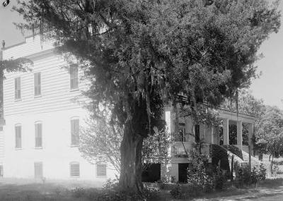
— Northampton Plantation 1940 © Library of Congress —
(Prints & Photographs Division HABS SC,8-PINOP.V,1--1)
Basic Information
- Location – Submerged under Lake Moultrie, St. John's Berkeley Parish, Berkeley County
Plantation lands were originally located five miles west of present-day Bonneau.
- Origin of name – ?
- Other names – North Hampton
- Current status – In 1939, work began on the Santee Cooper Hydroelectric and Navigation Project. This project displaced many families and communities, and many historic homes were lost as the area was flooded.
Timeline
- Circa 1700 – Earliest known date of existence (6)
Peter St. Julien acquired the property (6).
- ? – It appears Peter St. Julien gave the property to his son Benjamin St. Julien (6).
- 1716 – House built by Benjamin St. Julien (6).
- ? – Benjamin St. Julien died without a will and Northampton reverted back to his father Peter St. Julien (6).
- ? – Peter St. Julien passed away and left the plantation to his sister Elizabeth, who was married to General William Moultrie (6).
- Circa 1805 – General Moultrie's son inherited the plantation (6).
- ? – General Moultrie's son died at a young age, unmarried. The plantation was sold (6).
- ? – Theodore S. DuBose purchased Northampton (6).
- ? – Henry W. Ravenel bought the plantation from Theodore S. DuBose (6).
- ? – The plantation was purchased by Henry Le Noble Stevens (6).
- 1842 – The house caught fire and the upper story was destroyed. The "fortress-like walls" of the lower level and foundation were undamaged and the house was restored (6).
- ? – Percival Ravenel Porcher, a St. Julien descendant, acquired the plantation (6).
- ? – A. M. Barnes and Clarence Dillon purchased Northampton from Percival Ravenel Porcher (6).
Land
- Number of acres – 800
- Primary crop – Cotton and indigo (6)
Slaves
- Number of slaves – ?
References & Resources
- Northampton Historic Marker
- Diaries written at Northampton and Pooshee Plantations, 1865
- 30-15 Plantation File, held by the South Carolina Historical Society
- J. Russell Cross, Historic Ramblin's through Berkeley
(Columbia, SC: R.L. Bryan Company, 1985)
 Order Historic Ramblin's through Berkeley
 - Norman S. Walsh, Plantations, Pineland Villages, Pinopolis and Its People
(Virginia Beach, VA: Donning Company Publishers, 2007)
Order Plantations, Pineland Villages, Pinopolis and Its People
- Information contributed by Ramona Grimsley, Digital Projects Librarian for Berkeley County Library, from:
Sankofa's Slavery Data Collection