
Eutaw Plantation – Lake Marion – Orangeburg County
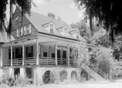
— Eutaw Plantation 1939 © Library of Congress —
(Prints & Photographs Division HABS SC-61)
Basic Information
- Location – Submerged under Lake Marion, St. John's Berkeley Parish, Orangeburg County
Original plantation lands were located near present-day Eutaw Springs and were between the Santee River and Eutaw Creek (1).
Eutaw was originally in Berkeley County, but in 1908 the county lines were redrawn and the plantation became part of Orangeburg County.
- Origin of name – Derived from its location on Eutaw Creek, which was in turn named for the Etiwan Indians (1).
- Other names – ?
- Current status – In 1939, work began on the Santee Cooper Hydroelectric and Navigation Project. This project displaced many families and communities, and many historic homes were lost as the area was flooded.
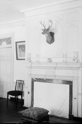
— Interior of Eutaw Plantation 1939 © Library of Congress —
(Prints & Photographs Division HABS SC-61)
Timeline
- 1770 – Earliest known date of existence
James Sinkler received a land grant. He developed his plantation, Belvidere, on part of the land and later gave a tract to his son, William, as a wedding gift (1).
- 1808 – House built (1)
William built a house on his property as well as a race track for the thoroughbred horses he bred. He called his plantation Eutaw (1).
- 1860s – During the Civil War, Union General Hartwell made the house at Eutaw his headquarters; one of the plantation's outbuilding served as a hospital for Northern soliders. The Sinkler women remained at Eutaw during its occupation, living on the upper floor of the house (1).
- 1939 – Work began on the Santee Cooper Hydroelectric and Navigation Project. Eutaw Plantation was still owned by the Sinkler family when it was destroyed by this project (1).
Land
Slaves
- Number of slaves – ?
Buildings
- House plan - rough sketch, 1940
- Front of house - photograph
References & Resources
- Waterman Report of 1939 - transcription - includes history of region, architectural analyses of homes
– Eutaw Plantation
– Eutaw Plantation House - photographs, drawing
- 30-15 Plantation File, held by the South Carolina Historical Society
- Anne Sinkler Fishburne, Belvidere, A Plantation Memory
(Columbia, SC: University of South Carolina Press, 1949)
 Order Belvidere, A Plantation Memory